
Advance Flight Technologies - 2015/05
RCFlyMaps: An interactive app for aeromodelers
The advent of FPV and other advanced flight technologies has radically altered the practice of model aviation over the past few years. It has touched nearly every aspect of the hobby, but none more critical than where and when people fly.
For decades, most RC flying has taken place at established, AMA-chartered fields, along with an occasional sojourn to a secluded park or unused schoolyard. The reason for making the trip was simple: seeing the machine fly. The location mattered only insofar as it was safe and convenient. It's hard to beat a purpose-built facility for safety and convenience.
That started to change approximately four years ago when people like us, the Roswell Flight Test Crew, stumbled onto the scene. With onboard cameras and FPV gear, we were less interested in watching the aircraft itself perform and much more interested in the cool video we could capture with it.
Needless to say, flying over the same barren patch of ground day after day doesn't yield much in the way of cool video, so we abandoned established flying sites in favor of locations that would have been unthinkable for model aviation in years past: famous landmarks and other exotic venues.
This has provided some amazing opportunities, but it also created two major problems. First, it isn't always clear where it's safe, prudent, or even legal to fly. Second, when we left the established flying fields behind, we cut ourselves off from the knowledge, friendships, and community that they provided.
An avid aeromodeler, Dale Jones of Gig Harbor, Washington, recognized these problems and decided to do something about them.
RCFlyMaps
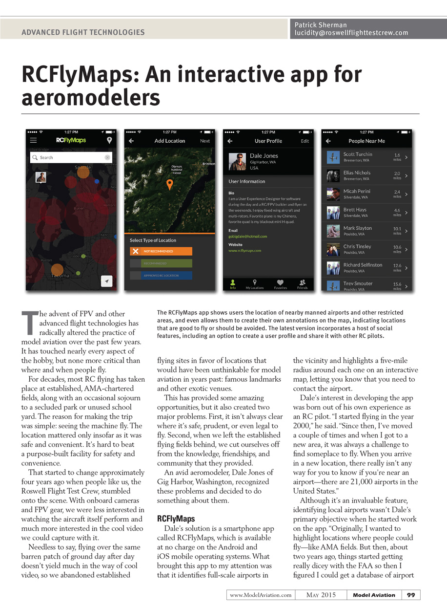
Dale's solution is a smartphone app called RCFlyMaps, which is available at no charge on the Android and iOS mobile operating systems. What brought this app to my attention was that it identifies full-scale airports in the vicinity and highlights a five-mile radius around each one on an interactive map, letting you know that you need to contact the airport.
Dale's interest in developing the app was born out of his own experience as an RC pilot. "I started flying in the year 2000," he said. "Since then, I've moved a couple of times and when I got to a new area, it was always a challenge to find someplace to fly. When you arrive in a new location, there really isn't any way for you to know if you're near an airport—there are 21,000 airports in the United States."
Although it's an invaluable feature, identifying local airports wasn't Dale's primary objective when he started work on the app. "Originally, I wanted to highlight locations where people could fly—like AMA fields. But then, about two years ago, things started getting really dicey with the FAA so then I figured I could get a database of airport locations and add those into the app."
Taking that step meant involving some friends in the project. In his day job, Dale works as a freelance user-experience architect for companies that are developing mobile apps for smartphones. He is responsible for creating the part of the app that you see: the interface, including the graphics you interact with on the screen. That's a different skill set than managing a database with thousands upon thousands of individual elements, capable of being accessed by hundreds of thousands of users in real time, so he brought some data-handling experts onboard. "I started working with them in May of 2014," Dale told me. "They helped me get to version one of the software—which is an enterprise-level product."
In the Cloud
All of the information that is accessible through Dale's app resides in the cloud. In other words, it is part of an online database that can be changed or updated at a moment's notice. "Earlier this year, for example, when the Super Bowl was being played in Glendale, Arizona, the FAA established a Temporary Flight Restriction in a 60-mile radius around the stadium," Dale said. "It was simple for me to go in and update the database to reflect that."
The RCFlyMaps app shows users the location of nearby manned airports and other restricted areas, and even allows them to create their own annotations on the map, indicating locations that are good to fly or should be avoided. The latest version incorporates a host of social features, including an option to create a user profile and share it with other RC pilots.
Transcribed from original scans by AI. Minor OCR errors may remain.

