Home
  • Home
  • Browse All Issues
  • Model Aviation.com

Conservation Drones - 2015/04

Author: Heather R. Taft Ph.D


Edition: Model Aviation - 2015/04
Page Numbers: 31,32,33,34,35

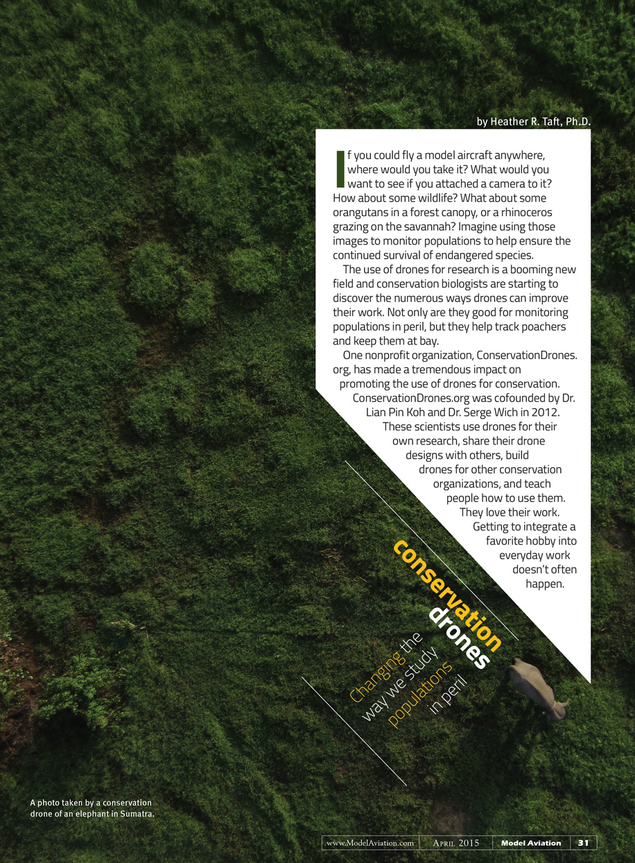
If you could fly a model aircraft anywhere, where would you take it? What would you want to see if you attached a camera to it? How about some wildlife? What about some orangutans in a forest canopy, or a rhinoceros grazing on the savannah? Imagine using those images to monitor populations to help ensure the continued survival of endangered species.
The use of drones for research is a booming new field and conservation biologists are starting to discover the numerous ways drones can improve their work. Not only are they good for monitoring populations in peril, but they help track poachers and keep them at bay.
One nonprofit organization, ConservationDrones.org, has made a tremendous impact on promoting the use of drones for conservation. ConservationDrones.org was cofounded by Dr. Lian Pin Koh and Dr. Serge Wich in 2012.
These scientists use drones for their own research, share their drone designs with others, build drones for other conservation organizations, and teach others how to use them. They love their work. Getting to integrate a favorite hobby into everyday work doesn’t often happen.

An Idea Is Born
Lian Pin, originally from Singapore, received his Ph.D. from Princeton University, located in Princeton, New Jersey, in 2008. While there, he was introduced to model aviation and, for a time, was an AMA member. He is now an associate professor of conservation ecology at the University of Adelaide, in Adelaide, South Australia.
Serge hales from the Netherlands and now serves as a professor of primate biology at Liverpool John Moores University, in Liverpool, England, and an honorary professor for the conservation of great apes at the University of Amsterdam, in Amsterdam, Netherlands.
The two met in Zurich in 2011 to discuss the challenges of wildlife conservation in Southeast Asia, and came up with an idea about a new way to gather data from rainforests. Lian Pin thought he could use model aircraft to gather some good data from cameras attached to model airplanes flown above the trees.
Studying orangutans in the Sumatran rainforest usually involves organizing expeditions that can last several weeks. Such expeditions are time-consuming and expensive, but more importantly, you may never see an orangutan while you are out. How frustrating! Serge had been doing these expeditions for years.
Lian Pin’s favorite experience so far in flying a conservation drone was his first flight over the Sumatran rainforest. “When our prototype drone, which is basically just a HobbyKing Bixler fitted with an ArduPilotMega v1.1, safely returned to us after a 20 km [approximately 12.5 miles] mission, the GoPro camera brought back amazing video footage of the rainforest. We felt for the first time like birds flying over those trees!” he said.
Lian Pin and Serge began to realize the myriad applications for drones in conservation research, and how huge their impact could be. They realized that others could also benefit from this method of gathering data.
Where does the money for drone testing come from? ConservationDrones.org has received support from multiple organizations, including National Geographic, World Wildlife Fund, DroneMapper, and DIYDrones.

What Constitutes a Conservation Drone?
Conservation drones consist of an airframe, an autopilot system, a camera, and software to program the aircraft. Airplanes, helicopters, and multirotors have all been used in the field.
Lian Pin uses the ArduPilot Mega (APM) to autopilot the drones, which includes a computer processor, GPS, data logger, pressure and temperature sensor, airspeed sensor, triple-axis gyro, and accelerometer. According to Lian Pin and Serge, most RC model airplanes could be converted to autonomous drones by simply combining open-source mission planner (APM Planner) software and the APM.
In the organization’s June 2012 issue of e-newsletter Tropical Conservation Science, Lian Pin and Serge said they tested a Canon IXUS 220 HS and a Pentax Optio WG-1 GPS in the prototype drone for taking still pictures. A small rectangle removed from the bottom of the fuselage allows the camera lens to extend. For videos, Lian Pin prefers to use a GoPro HERO attached to the underside of an airplane.
Lian Pin gave a presentation on using drones for conservation at a TEDGlobal conference, held June 11, 2013, at the Edinburgh International Conference Center, in Edinburgh, Scotland. He said during his speech that increased distance, ruggedness, and payload are important for expanding ConservationDrones.org’s applications.
Keeyan Pang, who volunteers for ConservationDrones.org, recently modified a Zeta Science FX79 flying wing that was able to fly 100 km (slightly more than 62 miles) in roughly two hours with winds ranging from 10 to 30 km (roughly 6 to 18 mph) per hour!

How Conservation Drones Work
The drones are programmed to take off with a simple toss in the air and fly their mission. In his TEDGlobal presentation, Lian Pin said that during these flights, “We will go grab ourselves a cup of coffee, sit back, and relax for the next few minutes, although some of us sit back and panic for the next few minutes worrying that the drone will not return. Usually it does, and when it does, it even lands automatically.”
In the Sumatran rainforests, space for an autonomous landing is a luxury. A controlled descent may be necessary to circle the airplane for a landing in a small open area.
The cameras on the drones take continuous video surveillance during flight, or are programmed to take still pictures at specific times or locations. Videos can ascertain whether particular species are present in an area and help determine population densities.
To monitor certain landmarks, Lian Pin and Serge have programmed their drones to fly between specified locations to take photos and then return home. This can be done by programming the flight path to certain points over a broad range, such as along a river, or using a grid pattern to ensure entire regions are monitored.
All flight plans are based on specific questions to aid research efforts, such as: is poaching activity occurring in this region? Or, are orangutans nesting in this area of the forest? Mission planning is done on the ground before takeoff. The length of the mission depends on what is being surveyed. They can last anywhere from 10 minutes to an hour.
“Perhaps the most exciting part about taking pictures from the air is we can later stitch these pictures together using special software to create a map of the entire landscape,” said Lian Pin in his TEDGlobal speech. Repeated surveillance of the area allows him to monitor changes in land use, such as reduced forest area and locations of fires. Images can even be processed to create 3-D models of the forest.

Problems and Solutions
There are several issues using drones for scientific research. Some of them are as follows:

Space: When asked about obstacles that he experiences in the field with drones that hobbyists might not regularly encounter, Lian Pin said, “The lack of landing space! It is always a challenge having to land our drones in a confined space of no more than 300 x 300 feet.”
Lian Pin has tried several methods for landing the airplanes in small areas. One method is catching the drone. This can be a useful and easy method if you have quick hands.
Another method Lian Pin has implemented is a net system, where several colleagues hold up a large sheet that the airplane can fly into during landing. This is a similar idea to the crash barriers found on aircraft carriers.
A third method of landing in small spaces that Lian Pin and his colleagues have been testing involves using a parachute attached to the underside of the fuselage. The videos look promising, but the parachute adds some weight and reduces aerodynamics, which could impede the distance an aircraft could travel. These last two landing methods also necessitate a formidable drone design able to withstand repeated rough landings.
Headwinds: If the aircraft is fighting strong winds it won’t be able to travel as far during a flight, reducing the data gathered. In an online conservation journal named Tropical Conservation Science, Lian Pin and Serge have noted the tendency for the airplane to meander when winds are high, reducing flight distance even more. They recommend only operating a drone when winds are less than 10 km (roughly 6 mph) per hour.
Environmental effects: Drones can be flown in moist environments including snow-covered ground, after rains, early in the morning when dew still covers vegetation. Some can even take off and land on bodies of water. Waterproofing the servos can help prevent damage, but won’t prevent all issues.
“The toughest drone I’ve had to build was to modify the ParkZone ICON A5 for flying over coral reefs in Belize,” noted Lian Pin. “I had no idea how corrosive that environment was. The electronics were starting to rust on the second day we were out on the reef! In the end, we gave up on the idea of creating a drone that could take off and land on the ocean. It was just not practical.”
Rough landings: For all pilots, mishaps happen and unexpected landings occur. Whether this is because of pilot error or unexpected environmental effects, spare parts may be necessary. Packing plenty of parts before leaving for the field is critical, but they’ve found that they can’t anticipate all the components that might be needed to make repairs. Obtaining spare parts while visiting new countries is tough. The pilots have to find stores that sell the specific damaged part.
In one instance, Lian Pin was in India helping the Wildlife Institute of India start using drones for research. He urgently needed a replacement battery and posted his problem on ConservationDrones.org’s Facebook page asking more than 1,000 subscribers from around the world if they knew somewhere in Delhi where he could purchase the item. He managed to get what he needed within 24 hours!

A Tool for Conservation Professionals
Conservation is a field particularly lacking in financial support. Implementing drones to gather data could have a substantial impact on the allocation of monetary resources, enabling more data to be collected at a reduced cost. With the introduction of drones, it is possible to cover a larger area. Transportation costs will decrease as well because a drone can scout an area before sending humans into the field.
One issue faced by conservation researchers is ensuring minimal impact on the environment while in the field. Sending drones to scout an area can focus human interest on locations where, for example, orangutan activity is present, completely eliminating the impact of humans.
Using drones can also have a direct impact on the survival of researchers. Sometimes field work can involve using airplanes or helicopters that fly relatively low to the ground to find populations of animals. This can be very dangerous and accidents can happen. Using a drone to gather information eliminates the risk to pilots and the researchers onboard.
Wildlife rangers in areas such as Nepal, who patrol vast expanses of land, also risk potentially life-threatening encounters with poachers. Not only will drones enable them to patrol land to find out where exactly poachers are, the presence of drones helps scare poachers off, and photos from the drones can be used to later identify the poachers.

Drones in the Field
Since the idea of using drones for conservation has begun to catch on, Lian Pin and Serge have helped modify and test drones for many uses. Organizations and researchers worldwide have started using them for different purposes.
Detecting and photographing birds has been enhanced by the use of drones. Jarrod Hodgson and Rohan Clarke are researchers at Monash University in Australia. They used a multirotor to assess nest densities of birds on the ground and in trees. Nest checks can also be performed much easier with a drone than in person, although great caution is warranted not to disturb chicks.
Bat researchers have used drones to detect bat sounds at night by suspending a recording device from a quadcopter. Using the drone allows researchers to record data in locations where there are no structures to mount a recording device, and to easily move the recording device to new locations.
Other animals that have been monitored using drones include turtles, tigers, rhinos, and elephants.
New applications are arising all the time. ConservationDrones.org currently has plans to start a flight school, where researchers can be trained on the type of drone to use for their needs and the equipment necessary for the job they want to perform. The school will also include information on how to program the drone, and how to download data from the drone or stream it back to a computer while the drone is in flight.

US Drone Regulations
In the US, drones are getting a bad reputation for near misses with passenger airplanes and irresponsible use by a small number of people. In turn, FAA regulations have become severely restrictive for everyone.
It is difficult to obtain an airworthiness certificate to fly drones, forcing scientists who want to use them for research to set up studies in foreign countries. They can’t teach their students in the US how to use them to gather data.
“I can understand how tempting and thrilling it is to fly high above the clouds, or close to people and property,” said Lian Pin, “so I do see the risk of having many inexperienced pilots operating over populated areas, and agree with the need for some form of safeguard to avoid causing harm to people and property. After the proper regulatory framework is put in place, drones could be a hugely important technology for a wide variety of applications.”

Conclusion
Lian Pin is busy these days, “I hardly get to do recreational flights anymore. My go-to aircraft for fun nowadays is a 250-size mini quadcopter for FPV that I fly among the eucalyptus trees in my backyard!” It’s fun, but also another great tool to use in the field.
Watch for this organization to continue to transform conservation research around the world. Lian Pin shared that ConservationDrones.org is working with US-based group Conservation International to help start programs in other countries that would use drones to map and monitor habitats and wildlife. The organization was a finalist for the 2014 Tech Awards presented by The Tech Museum of Innovation in San Jose, California
To learn more about Conservation Drones.org, its founders, and projects the organization is aiding, visit its website. Fellow hobbyists can support this organization by donating spare parts for research via the website, or by getting involved in the development of new features on both ConservationDrones.org and DIY Drones.
Do you specialize in a field that could aid drone design? This is an exciting opportunity to give your input on improving drones for research!

ama call to action logo
Join Now

Model Aviation Live
Watch Now

Privacy policy   |   Terms of use

Model Aviation is a monthly publication for the Academy of Model Aeronautics.
© 1936-2025 Academy of Model Aeronautics. All rights reserved. 5161 E. Memorial Dr. Muncie IN 47302.   Tel: (800) 435-9262; Fax: (765) 289-4248

Park Pilot LogoAMA Logo