
Radio Control Slope Soaring
Dave Garwood [[email protected]]
Let's consider capped landfills as slope-soaring sites.
Also included in this column:
- A pair of onboard electronic data-recording devices
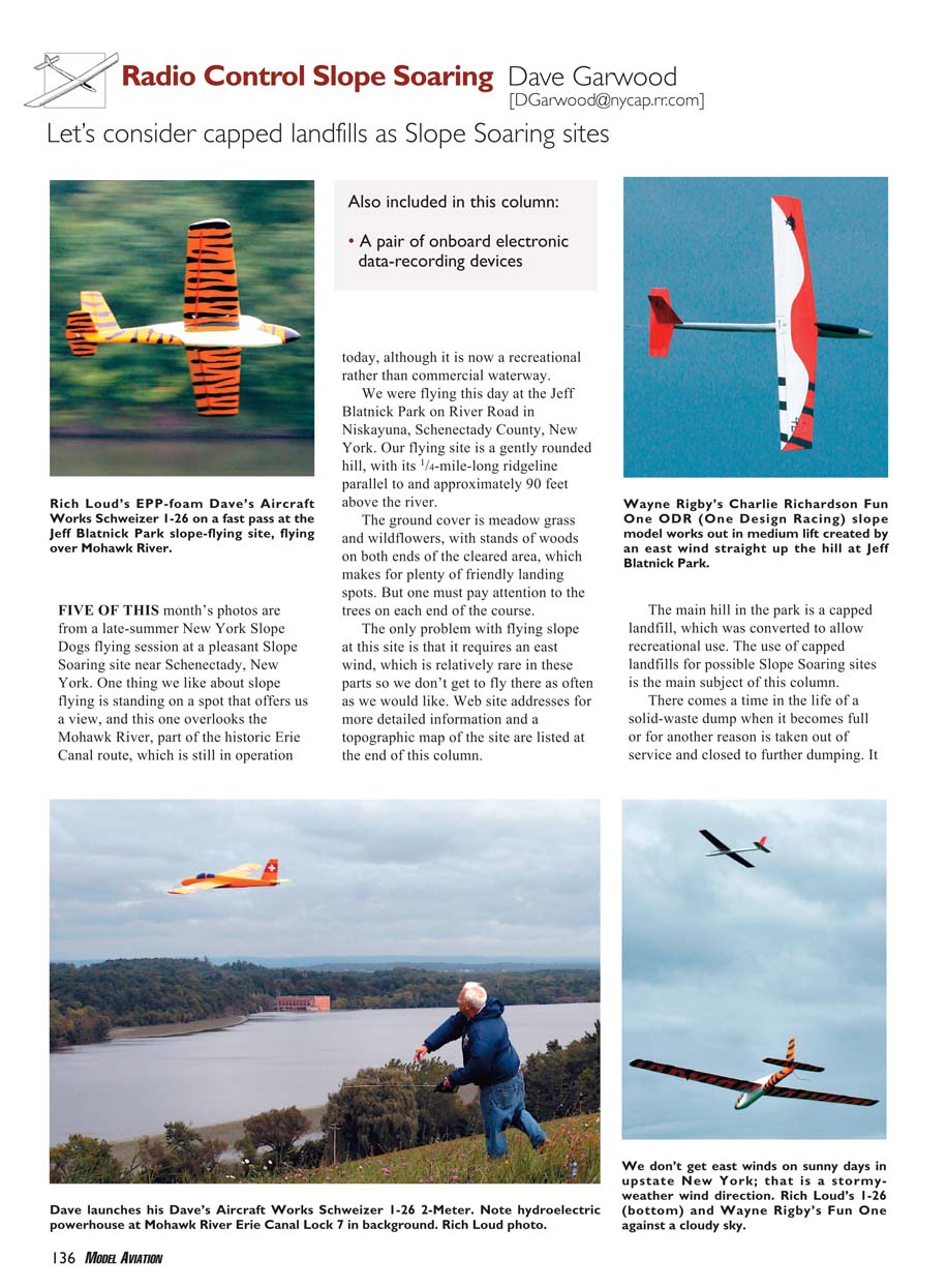
FIVE OF THIS month's photos are from a late-summer New York Slope Dogs flying session at a pleasant slope-soaring site near Schenectady, New York. One thing we like about slope flying is standing on a spot that offers us a view, and this one overlooks the Mohawk River, part of the historic Erie Canal route, which is still in operation today, although it is now a recreational rather than commercial waterway.
We were flying this day at the Jeff Blatnick Park on River Road in Niskayuna, Schenectady County, New York. Our flying site is a gently rounded hill, with its 1/4-mile-long ridgeline parallel to and approximately 90 feet above the river.
The ground cover is meadow grass and wildflowers, with stands of woods on both ends of the cleared area, which makes for plenty of friendly landing spots. But one must pay attention to the trees on each end of the course.
The only problem with flying slope at this site is that it requires an east wind, which is relatively rare in these parts, so we don't get to fly there as often as we would like. Web site addresses for more detailed information and a topographic map of the site are listed at the end of this column.
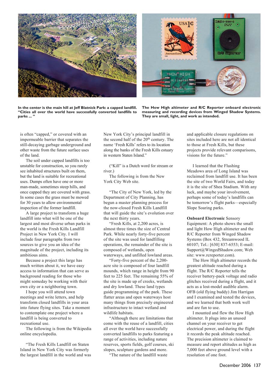
The main hill in the park is a capped landfill, which was converted to allow recreational use. The use of capped landfills for possible slope-soaring sites is the main subject of this column.
There comes a time in the life of a solid-waste dump when it becomes full or, for another reason, is taken out of service and closed to further dumping. It is often "capped," or covered with an impermeable barrier that separates the still-decaying garbage underground and other waste from the future surface uses of the land. The soil under capped landfills is too unstable for construction, so you rarely see inhabited structures built on them, but the land is suitable for recreational uses. Dumps often have one or more man-made, sometimes steep hills, and once capped they are covered with grass. In some cases the grass must be mowed for 30 years to allow environmental inspection of the former landfill.
A large project to transform a huge landfill into what will be one of the largest and most diverse urban parks in the world is the Fresh Kills Landfill Project in New York City. I will include paragraphs from two sources to give you an idea of the magnitude of the project, including its ambitious aims. Because a project this large has much written about it, we have easy access to information that can serve as background reading for those who might someday be working with their own city or a neighboring town. I hope you will attend town meetings and write letters, and help transform closed landfills in your area into future flying sites. Take a moment to contemplate one project where a landfill is being converted to recreational use. The following is from the Wikipedia online encyclopedia.
"The Fresh Kills Landfill on Staten Island in New York City was formerly the largest landfill in the world and was New York City's principal landfill in the second half of the 20th century. The name 'Fresh Kills' refers to its location along the banks of the Fresh Kills estuary in western Staten Island.
('Kill' is a Dutch word for stream or river.)"
The following is from the New York City Web site.
"The City of New York, led by the Department of City Planning, has begun a master planning process for the now-closed Fresh Kills Landfill that will guide the site's evolution over the next thirty years.
"Fresh Kills, at 2,200 acres, is almost three times the size of Central Park. While nearly forty-five percent of the site was used for landfilling operations, the remainder of the site is composed of wetlands, open waterways, and unfilled lowland areas.
"Forty-five percent of the 2,200-acre site is composed of four landfill mounds, which range in height from 90 feet to 225 feet. The remaining 55% of the site is made up of creeks, wetlands and dry lowland. These land types guide programming of the park. These flatter areas and open waterways host many things from precisely engineered infrastructure to intact wetland and wildlife habitats.
"Although there are limitations that come with the reuse of a landfill, cities all over the world have successfully converted landfills to parks featuring a range of activities, including nature reserves, sports fields, golf courses, ski slopes, sculpture gardens and more.
"The nature of the landfill waste and applicable closure regulations on sites included here are not all identical to those at Fresh Kills, but these projects provide relevant comparisons, visions for the future."
I learned that the Flushing Meadows area of Long Island was reclaimed from landfill use. It has been the site of two World Fairs, and today it is the site of Shea Stadium. With any luck, and maybe your involvement, perhaps some of today's landfills can be tomorrow's flight parks—especially slope-soaring parks.
Onboard Electronic Sensory Equipment
A photo shows the small and light How High altimeter and the R/C Reporter from Winged Shadow Systems (Box 432, Streamwood, IL 60107; Tel.: (630) 837-6553; E-mail: [email protected]; Web site: www.rcreporter.com). The How High altimeter records the greatest altitude reached during a flight. The R/C Reporter tells the receiver battery-pack voltage and radio glitches received during a flight, and it acts as a lost-model audible alarm. OFB (old flying buddy) Jim Harrigan and I examined and tested the devices, and we learned that both work well and are fun to use.
I mounted and flew the How High altimeter. It plugs into an unused channel on your receiver to get electrical power, and during the flight it records the peak altitude reached. The How High altimeter is claimed to measure and report altitudes as high as 7,000 feet above ground level with a resolution of one foot.
The unit turns on when the receiver is powered up, and an LED blinks when operating to let you know it's working. The LED is also a sensing device. To read the stored altitude value after the flight, you wave your finger over the LED, and it blinks further to give you the value of the altitude recorded during the flight.
After the flight, and before turning off the receiver, you wave your finger over the LED. It begins to flash, and you count the flashes—one group of flashes for each of four digits in the altitude value. The instructions for wagging your finger over the LED are detailed, and I found it to work better in open shade than in direct sunlight.
The How High altimeter works as advertised, and it is fun to know the altitude you actually achieved in that "speck-out" flight. I did not have another way to measure my altitude, so I cannot comment on this unit's measurement accuracy.
Jim tested the R/C Reporter, which checks battery voltage before each flight, records radio interference during the flight and reports it at the end of the flight, and it includes an audible lost-airplane locator. Following are his remarks.
"The Lost Model Locator and Voltage Monitor features require no user interaction at all. Just plug the devices in and they will work. In case of a lost model, when the device detects that transmitter signal has been turned off it plays a melody.
"The way the 'check the voltage before each flight' feature works is by emitting a tone followed by a series of beeps that represent the voltage. If voltage is low, the warning given is a repeated series of 3 beeps.
"The Voltmeter feature requires two movements of the stick past 70% and the Glitch Counter three movements, but there is no annoying timing you have to get right. It just works and is easy and reliable.
"The way to measure the voltage reading is by moving the stick twice past 70% (within two seconds) and listening for a musical tone followed by a series of beeps. A series of five beeps followed by one beep followed by three beeps would indicate 5.13 volts.
"With a fully charged pack the voltmeter gave a reading about .03 volt higher than the two digital voltmeters I had connected. This is well within the specified accuracy range. The docs say 0.01v resolution and +-1.5% (FS) accuracy. (That works out to about +-0.07 volts so that third digit of resolution is of limited value.)
"As the voltage dropped near the 4.6 volt cutoff the accuracy was better and was usually within .01 volt of the meter reading. Once the voltage got below 4.6, the low voltage warning started and I had about 2.5 minutes of simulated flying before the servos stopped.
"Interestingly, the R/C Reporter seemed to die about two seconds before the airplane, so if you lose your airplane because you ran out of electrical power, you are not going to have a lost model alarm to help you find it.
"The glitch counter does a good job at counting missing pulses as described on the instruction sheet. However, when connecting voltmeters to the receiver circuit, sometimes the servos would jump around a bit, and this did not result in a reading.
"The device is not sophisticated enough to look at the width of the pulse and detect a pattern of interference that is not characteristic of stick movement. That would be very difficult to do without circuitry being built into the receiver itself and was not expected of this type of device."
Jim and I have concluded that the two Winged Shadow devices work as described. They are worthwhile additions to model flying if having this data is useful and interesting to you.
MA
Sources:
- slopeflyer.com — www.slopeflyer.com
- Niskayuna flying site — www.slopeflyer.com/artman/publish/article_53.shtml
- Slope Soaring sites in other states — www.slopeflyer.com/artman/publish/cat_index_15.shtml
- Topozone map: Jeff Blatnick Park, Schenectady County, New York — www.topozone.com/map.asp?lat=42.80361&lon=-73.8481
- Niskayuna Town Parks — www.niskayuna.org/Public_Documents/NiskayunaNY_Rec/Town_Parks
- Erie Canal (Wikipedia article and historic maps) — en.wikipedia.org/wiki/Erie_canal
- Fresh Kills Landfill (Wikipedia article) — en.wikipedia.org/wiki/Fresh_Kills_Landfill
- Fresh Kills Landfill (New York City Web site—extensive information) — www.nyc.gov/html/dcp/html/fkl/fkl_index.shtml
Transcribed from original scans by AI. Minor OCR errors may remain.

