
RC SLOPE SOARING
Dave Garwood, 5 Birch Ln., Scotia NY 12302; E-mail: [email protected]
ONE OF THE serious Slope Soaring pilots' core activities is finding new flying sites. Perhaps you have found slope venues by talking to club members and hobby-shop staff. Plenty of well-known flying sites are described on Soaring-club Web sites.
Beyond these known spots, you may want to strike out and find new flying locations. Even if you have a treeless, 900-foot escarpment at the end of your street, it's good to have sites that can be flown in other wind directions. This column will describe a software mapping program that will be a great help in learning about the landscape.
It's highly satisfying to be the first to find a new slope-flying site. These discoveries can come from being observant when driving or hiking a little farther down a ridge from which you currently fly.
Back in the day we used to study US Geological Survey (USGS) topographic quadrangle maps, paying close attention to the closeness of the contour intervals to judge a hill's steepness and the direction it faces. In New York and New England we have plenty of hills, but they are usually covered with trees that deny us a clear view of the sky, do not offer a landing area, and make it tough to recover a downed airplane. Another sterling feature of the USGS "quad" maps is that they depict vegetation and show areas of clear ground.
Studying topographic maps can lead us right to promising "undiscovered" flying sites, and they show proximity to roads and trails which indicate the accessibility of a potential flying site. However, the paper maps are an inefficient and costly way to review a great deal of territory.
Now there is a software program that includes USGS topographic maps for the entire USA, with a search engine that rapidly finds a location by town name, geologic feature name, ZIP code, street address, street intersection, or latitude/longitude coordinates.
DeLorme's Topo USA 5.0 includes full coverage of the US on a single DVD or six CDs. This program gives you five types of maps: USGS topographic, shaded relief, 3-D shaded relief, trail, and road. Topo USA 5.0 lets you plot routes and print the maps. Following are some of the things you can do with the program.
- Quickly see the lay of the land with contour intervals and shaded relief.
- See an elevation profile of the territory you are reviewing.
- Run the cursor over the top of the hill and the valley below, and see their elevations. Subtract the difference to calculate the hill's height.
- Zoom in through many levels of detail, noting the extent of tree cover, and look for possible open locations in wooded territory.
- Press the 3-D tab and see terrain from different angles. Circle a target spot such as a hawk, examining it from different perspectives. Adjust the pitch to see the terrain from different angles.
- Print two-dimension and three-dimension maps with route profiles.
- Load Global Positioning System (GPS) coordinates into your handheld GPS device.
I've included some sample maps and comparison photographs from some of the primo slope sites I've flown from in California, Utah, and Kansas. Also included is some data I obtained from the program about two of my local flying sites in New York.
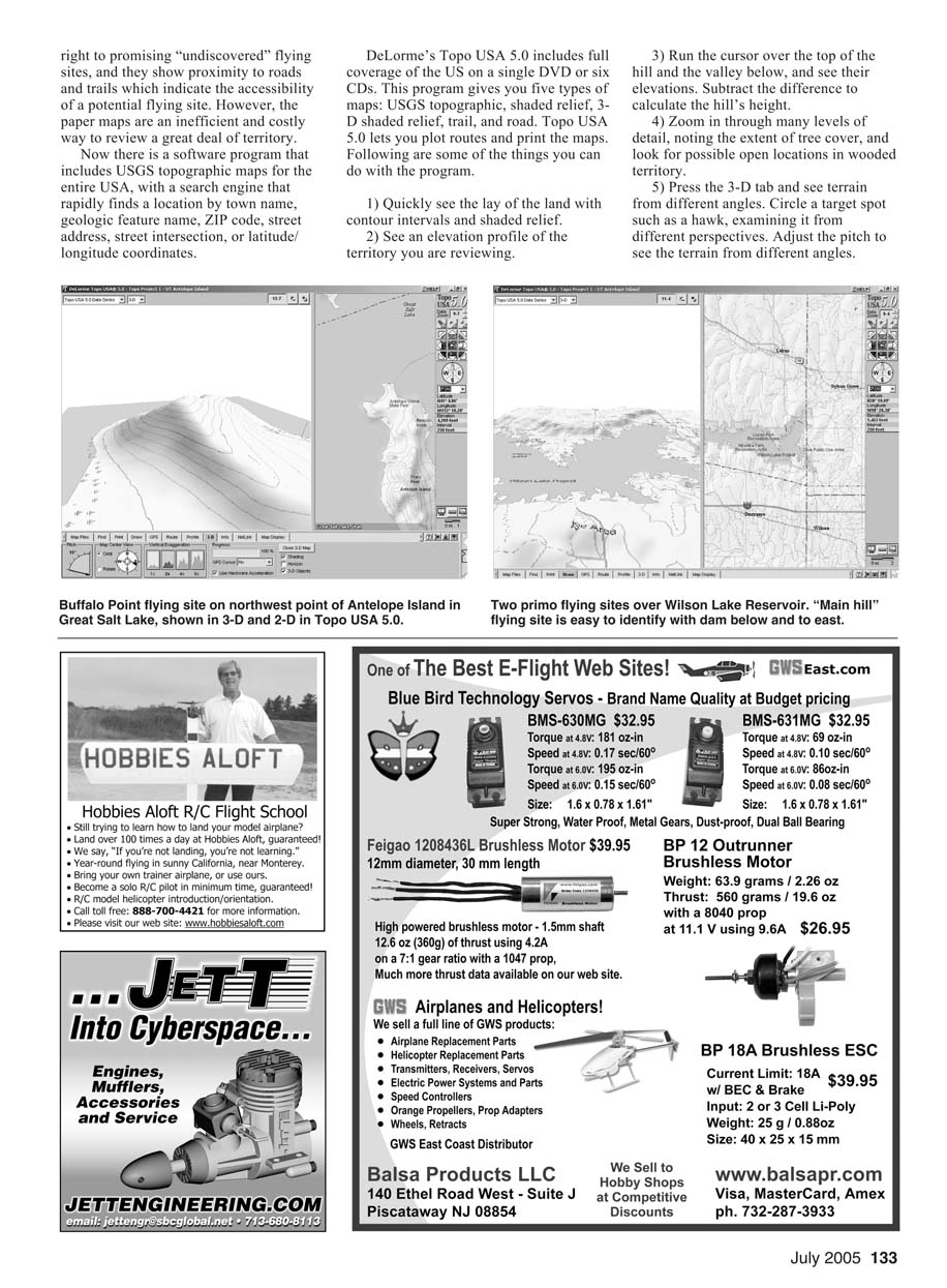
Cajon Summit, California: This is the flying site of the Southern California PSS (Power Scale Soaring) Festival. The main hills face south, toward the Los Angeles Basin, and the desert areas to the north and west of the ridge heat up during the day and draw air from below, through Cajon Pass and over the slope.
I found the map area by searching for "Cajon Summit" and quickly located the split in Interstate 15, which we can easily see from the flying site. This made it easy to identify the ridge from which we fly.
Passing the cursor over the lip of the ridge indicates that its altitude is 4,379 feet above sea level, and the valley floor measures 3,426 feet, giving a hill height of 953 feet. Also indicated is the main flying site's latitude of north 34 degrees 20.843 minutes and a longitude of west 117 degrees and 27.361 minutes.
Antelope Island, Utah: This slope-flying site features breathtakingly beautiful scenery. We flew from the northwest end of Antelope Island in the Great Salt Lake during Soar Utah 2000.
The search engine found "Antelope Island" in Arizona and South Dakota, but not in Utah. Searching for "Great Salt Lake" gets us exactly where we want to be. The program shows the island and the causeway that reaches from Syracuse, a suburb of Salt Lake City, to the island.
The topographic map shows Antelope Island to be devoid of trees and with several steep hills and water all around. It appears that the island could offer several flying sites in varying wind directions, especially if you don't mind a hike.
The altitude at the top reads 4,643 feet, and the lake level reads 4,190 feet, yielding a hill height of 553 feet at latitude north 41 degrees 1.97 minutes and a longitude of west 112 degrees and 15.80 minutes.
We flew with the InterMountain Silent Flyers off Buffalo Point, Utah, in a state park. To fly at other hills on the island, please take the time and effort to find the land owner(s) and get permission to fly.
Wilson Lake Reservoir, Kansas: This is the home of the Wings Over Wilson event. Find the main hill by searching for "Russell County"; searches for "Wilson Lake" and "Wilson Reservoir" find locations, but they are in states other than Kansas.
From Topo USA 5.0 we learn that the main contest flying site is 203 feet above the lake at latitude north 38 degrees 57.98 minutes and longitude west 98 degrees and 30.70 minutes. "Airport Hill"—just to the west at latitude north 38 degrees 57.204 minutes and longitude west 98 degrees 31.11 minutes—is probably the most productive 200-foot heavy sailplane hill I've ever flown from, and the map shows the grass landing strip that runs the length of the ridge.
You say you want to see your house on the computer screen? Even more data is available from the DeLorme Web site at www.delorme.com. You can download DeLorme Aerial Data Packets (ADPs), which include satellite images, aerial photos, and USGS 7.5-minute topo maps. These show:
- Residential, agricultural, or commercial development.
- Land cover, forest density, and clear-cuts.
- Radio towers, cemeteries, landing strips, and buildings.
- Roads or trails not included in the map data.
If you purchase Topo USA 5.0, you're entitled to download $50 worth of ADPs free. A sample CD with six fascinating ADPs is included with the program. Additional ADPs are available for $1 per square kilometer.
DeLorme's recommended minimum system requirements for running Topo USA 5.0 are:
- Microsoft Windows XP operating system.
- 256 MB RAM.
- 600 MHz Intel Pentium III (or equivalent) processor.
- 700 MB of available hard-disk space.
- Microsoft Internet Explorer version 5.0 or later.
- CD-ROM drive for CD version.
- DVD-ROM drive for DVD version.
Not mentioned are the video card requirements, which are important. In my testing, Topo USA 5.0 runs butter-smooth on an Intel Pentium 4, 3.0 GHz processor, and an 8 MB video card. Occasionally I get a message that reads "Video card unable to render this image." But as soon as I click it off, the image appears. A more capable graphics card with more onboard RAM might eliminate this message.
I loaded the map data to a SATA-150 hard drive for quicker search access and faster image loading. The single installation problem I had was a "Find tab did not initialize (ISO error)" message when using the search function. The DeLorme Web site has good troubleshooting information, and I quickly resolved my problem by downloading and installing the MagneticUpdate.exe program.
Topo USA 5.0 costs $99.95 and delivers a staggering amount of mapping data to your desktop or laptop computer. You can view sample screen images and more information about Topo USA 5.0 and other mapping programs and GPS devices at DeLorme's Web site.
Probably the most useful feature for me in Topo USA 5.0 is the ability to find clear areas in forested terrain. The program accurately depicts clear flying areas among forestland at two of my local flying sites.
To see examples, search for "Blatnick Park" in New York. The white area between the east border of the park and the Mohawk River is where we fly. Search for "Petersburg Pass" in New York. That is a hilly and wooded region, but that small white spot between the "Petersburg Pass" legend and the "Taconic Trails Ski Area" legend is our launch spot and landing zone. The 1,200-foot rise of this hill and the million trees below are seen just to the west northwest.
For photos of these flying sites, see slopeflyer.com or listings at www.slopeflyer.com/artman/publish/article_53.shtml and www.slopeflyer.com/artman/publish/article_52.shtml. MA
Transcribed from original scans by AI. Minor OCR errors may remain.

