
Slope Safari—New York to Kansas and back
by Dave Garwood [email protected]
In May 2012, I took a two-week driving trip—a Slope Safari—from my home in upstate New York to the Midwest Slope Challenge, located 96 miles from the geographic center of the United States. This was a "see the USA in your Chevrolet" type of trip and my intent was to fly at as many Slope Soaring sites as I could.
Almond Lake, Almond, New York
Slope Soaring pilots are forever looking out the windows as they drive, imagining that they might fly from this hill or that, and bingo! Sometimes we spot a new flyable slope.
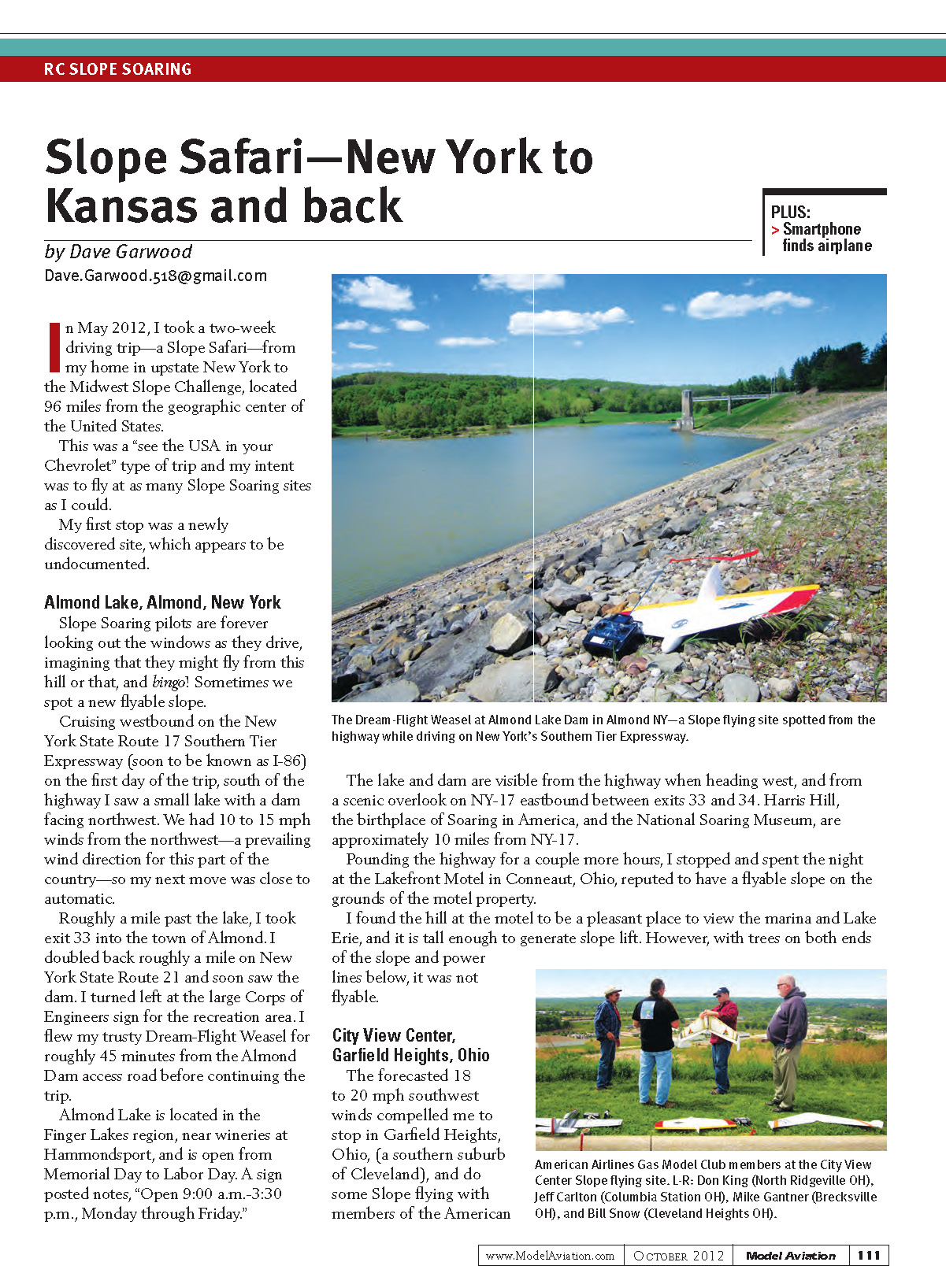
Cruising westbound on New York State Route 17 (the Southern Tier Expressway, soon to be I‑86) on the first day of the trip, I saw a small lake with a dam facing northwest. We had 10 to 15 mph winds from the northwest—a prevailing wind direction for this part of the country—so my next move was close to automatic.
Roughly a mile past the lake, I took exit 33 into the town of Almond. I doubled back about a mile on New York State Route 21 and soon saw the dam. I turned left at the large Corps of Engineers sign for the recreation area and flew my trusty Dream‑Flight Weasel for roughly 45 minutes from the Almond Dam access road before continuing the trip.
Almond Lake is located in the Finger Lakes region, near wineries at Hammondsport, and is open from Memorial Day to Labor Day. A sign notes, "Open 9:00 a.m.–3:30 p.m., Monday through Friday." The lake and dam are visible from the highway when heading west, and from a scenic overlook on NY‑17 eastbound between exits 33 and 34. Harris Hill, the birthplace of Soaring in America, and the National Soaring Museum are approximately 10 miles from NY‑17.
I pounded the highway for a couple more hours and spent the night at the Lakefront Motel in Conneaut, Ohio, reputed to have a flyable slope on the motel grounds. The hill at the motel is a pleasant place to view the marina and Lake Erie, and it is tall enough to generate slope lift. However, with trees on both ends of the slope and power lines below, it was not flyable.
City View Center, Garfield Heights, Ohio
The forecasted 18 to 20 mph southwest winds compelled me to stop in Garfield Heights, Ohio (a southern suburb of Cleveland), and do some slope flying with members of the American Airlines Gas Model Club. This is a highly accessible slope-flying site. Fliers park on pavement; you can park close enough to lean on your car and fly if you like. Cars are close for cold drinks in the summer and hand warming in the winter. There is a Steak 'n Shake for breakfast and lunch, and an Applebee's for dinner in the same plaza. We fly from behind a Giant Eagle grocery store.
On my visit I flew with Mike Gantner, Don King, Jeff Carlton, Ken Stroud, Bill Snow, and Joe Toth. I flew my Dream‑Flight Weasel. Mike, Don, and Jeff flew Slope Slayer KnifeEdge wings. Others flew Dave Sanders Foam‑51 EPP Mustangs, other 48‑inch wing designs, and some original-design slope airplanes. The lift was fine and the convenience of the site was unbeatable.
Wilson Lake, Lucas, Kansas
Wilson Lake was as far west as I drove—the centerpiece for this trip—and where the excellent 19th annual Midwest Slope Challenge was held. There, with the wind blowing in all directions, I flew from a grassy area overlooking Wilson Dam.
Wilson Lake has five flyable sites to handle five wind directions, and Kansas has plenty of wind.
For more coverage of the event, see Alex Paul’s article in the September 2012 issue of RC Soaring Digest online magazine and my article in the September 2012 issue of Flying Models magazine. See the official event website to get details on the 20th anniversary of the gathering.
Coronado Heights Park, Lindsborg, Kansas
This is a fascinating flying site because of its history and because the 300‑foot hill overlooking the Kansas prairie is flyable in three wind directions.
The Spanish conquistador Francisco Vásquez de Coronado trekked through the present‑day Southwestern and Central U.S. on his 1540–1542 expedition searching for the mythical Seven Cities of Gold. Although it is not known if Coronado actually ascended the heights now named after him, Spanish military artifacts found nearby underlie the story that the expedition reached this location.
Concluding the week at Wilson Lake, I headed for the Heights after a National Weather Service forecast of "south wind 14 to 17 mph, increasing to 23 to 26 mph. Winds could gust as high as 36 mph." When I got there, the winds were a steady 35 mph, gusting to 39 mph. Sand and dirt were blowing enough to cause discomfort and I decided not to launch on an unfamiliar hill.
The park has interesting stone buildings and picnic areas and a 3.2‑mile mountain bike trail. The views of the prairie in all directions are impressive, and with an abundance of cleared land for landing, this is an inviting flying location. Local fliers favor northwest and south winds, but the east wind is also flyable. I’ll return to Coronado Heights to fly.
Brookville Dam, Brookville, Indiana
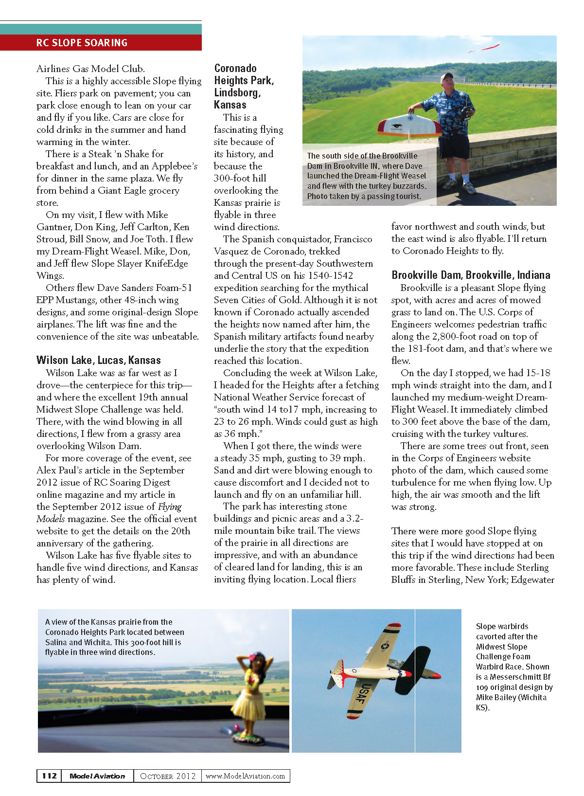
Brookville is a pleasant slope‑flying spot, with acres and acres of mowed grass to land on. The U.S. Corps of Engineers welcomes pedestrian traffic along the 2,800‑foot road on top of the 181‑foot dam, and that’s where we flew.
On the day I stopped we had 15–18 mph winds straight into the dam, and I launched my medium‑weight Dream‑Flight Weasel. It immediately climbed to about 300 feet above the base of the dam, cruising with the turkey vultures.
There are some trees out front, visible in the Corps of Engineers website photo of the dam, which caused some turbulence when flying low. Up high, the air was smooth and the lift was strong.
There were more good slope‑flying sites I would have stopped at on this trip if wind directions had been more favorable. These include Sterling Bluffs in Sterling, New York; Edgewater State Park on Lake Erie, Cleveland, Ohio; Sleeping Bear Dunes in Traverse City, Michigan; Mount Baldy at Indiana Dunes National Lakeshore; and Breezy View Park in Columbia, Pennsylvania. Maybe you'll fly at one or more of these spots in the next year. I hope to visit them on my next trip.
To find out more about the locations along my Slope Safari, visit www.slopeflyer.com.
Smartphone Aids Search
My friend and flying buddy Jim Harrigan found my lost RC model using his smartphone.
We were flying together at a town park's model airplane flying field when my model stopped responding to transmitter stick movements. The polyhedral glider drifted downwind gracefully because of its stability. It traveled approximately a half‑mile while I furiously wiggled the sticks and turned the transmitter off and on, to no avail. The model crossed a soccer field and a cornfield, hit a tree line, and fell from sight.
Jim carefully observed where he saw the airplane go down and called out the possible location—presumably to fix it in his memory and mine. "Sighting over the center of those two soccer goals points to where I think I saw the plane hit the trees and fall," he said. Having the pilot or a flying buddy observe where the model is last seen is the biggest advantage in finding a lost model.
We drove to the neighborhood on the side of the tree line opposite the cornfield, where a homeowner gave us permission to start from his yard and search the tree line. On the first pass we found nothing.
We returned to the car to charge the transmitter and see if we could hear servo movement or other noise from the model. At that point we did not know if it had fallen to the ground or was still in the trees.
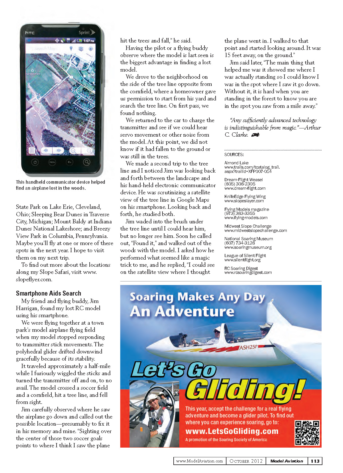
On the second trip to the tree line I noticed Jim looking back and forth between the landscape and his handheld electronic communicator device. He was scrutinizing a satellite view of the tree line in Google Maps on his smartphone. Looking back and forth, he studied both.
Jim waded into the brush under the tree line until I could hear him but could no longer see him. Soon he called out, "Found it," and walked out of the woods with the model. I asked how he performed what seemed like a magic trick, and he replied, "I could see on the satellite view where I thought the plane went in. I walked to that point and started looking around. It was 15 feet away, on the ground."
Jim said later, "The main thing that helped me was it showed me where I was actually standing so I could know I was in the spot where I saw it go down. Without it, it is hard when you are standing in the forest to know you are in the spot you saw from a mile away."
"Any sufficiently advanced technology is indistinguishable from magic." — Arthur C. Clarke
SOURCES
- Almond Lake
www.trails.com/tcatalog_trail.aspx?trailid=XFP007-014
- Dream‑Flight Weasel
(805) 308-2305 www.dream-flight.com
- KnifeEdge Flying Wing
- Flying Models magazine
(973) 383-3355 www.flying-models.com
- Midwest Slope Challenge
- National Soaring Museum
(607) 734-3128 www.soaringmuseum.org
- League of Silent Flight
- RC Soaring Digest
Transcribed from original scans by AI. Minor OCR errors may remain.

